 As a civil engineering firm, we always look for new technologies and tools to help us do our jobs better. One tool that is revolutionizing the process of surveying a site for construction is laser scanning. With laser scanning tools, civil engineers and surveyors can get more accurate data, save time on site visits, and provide even more precise information for future construction design planning.
Laser scanning is also known as LiDAR or High Definition Surveying (HDS). These tools allow surveyors to capture 3D measurements of a construction site more accurately than traditional survey methods. The gathered measurements are also easy to integrate into 3D building model software and BIM designs. Precise data points collected with laser scanning tools provide an accurate framework of a construction site or existing structure that can guide the design of a new construction or renovation project. Unlike traditional surveying methods involving regular site visits, manual measurements, and extensive records keeping laser scanning has emerged as a faster, more accurate, and cheaper tool for surveying purposes.
The benefits of laser scanning
- Accuracy: Laser scanning can pinpoint data points with sub-millimeter accuracy, a rate that traditional surveying methods can’t beat. These exact measurements offer enhanced insight into a structure or site that can aid architects and construction professionals in the design and building process.
- Documentation: Laser scanning systems can create accurate replicas of sites, which are easily uploaded to design software to create digital blueprints, 3D modeling plans and more. This level of documentation prevents errors from incomplete or outdated survey data that are common in traditional surveying.
- Cost savings: Laser scanning is faster and more cost-effective than traditional mapping methods, saving up to 50% in project costs and significantly boosting profitability.
- Shared access: Laser scans are easier to share between trades on a job site, facilitating better communication and coordination among team members. Sharing this data also helps reduce confusion on the site, improves productivity, and reduces errors.
How is laser scanning utilized in surveying?
Surveying has embraced laser scanning because of the immense amount of precise data that can be provided with less work and at a lower cost. Some of the most common uses of laser scanning in surveying processes include:
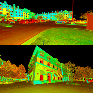
- Capturing 3D data: Laser scanners emit laser beams that bounce off surfaces and return to the scanner. The time it takes for the beam to return is used to calculate distances, creating a “point cloud” of millions of data points representing the surveyed area or object in three dimensions.
- Site analysis and topographic mapping: The collected data is easy to process into detailed maps and models that accurately describe site conditions in a topographical map format. This is especially useful for understanding a site’s natural features.
- Design integration: The data collected by laser scanners is easily integrated into design software to create BIM models. This integration saves significant time during the design phase of a project, especially compared to tonal station or GPS surveying methods, which require more site visits and manual labor.
Project Spotlight: Wolverine Crossing
Our team utilized laser scanning for the Wolverine Crossing project. This project, which included an ALTA/NSPS Land Title survey, required a full survey of the existing housing campus at Utah Valley University. To perform this task, we utilized a Leica P40 scanner to capture 3D images and measurements of the property.
A Leica P40 scanner is a 3D laser scanner that captures precise measurements. It has a scan rate of 1 million points per second, a range of up to 270m, and produces highly detailed 3D color point clouds with HDR imaging. It can operate in harsh conditions, such as low temperatures of -20°C to +50°C, and is water and dust-resistant. This tool captures floor plans, topographic maps, and 3D data for BIM designs.
We got some excellent measurements using the Leica P40 scanner. When we analyzed this data using specialized software, we created a detailed land parcel map for the university. This map included measurements of all the properties on the land. We integrated our findings from the land title survey to provide accurate measurements of any property boundaries and easements on the property. The full report provided the university with an extensive road map of the housing campus and insight into any improvements that may be needed in the future.
Laser scanning is the future of surveying
Incorporating laser scanning tools into our surveying process has proven to be a game-changer for our team. Not only do these tools provide unparalleled accuracy and efficiency, but they also help us deliver exceptional results for our clients. We gained so much insight into the value these tools can provide on the Wolverine Crossing project, and we provided the university with the detailed data they needed to make informed decisions about the future of the housing campus structures and land.
We continue to embrace advanced technologies like laser scanning and tools like the Leica P40 scanner in our surveying work. We’ve seen firsthand how these tools can streamline workflows, reduce costs, and enhance collaboration. Whether it’s a university housing campus, a commercial development, or a large-scale infrastructure project, laser scanning allows us to provide the precision and insight our clients need to succeed. So, if you’re ready to explore how laser scanning can elevate your next project, our team is here to help.

